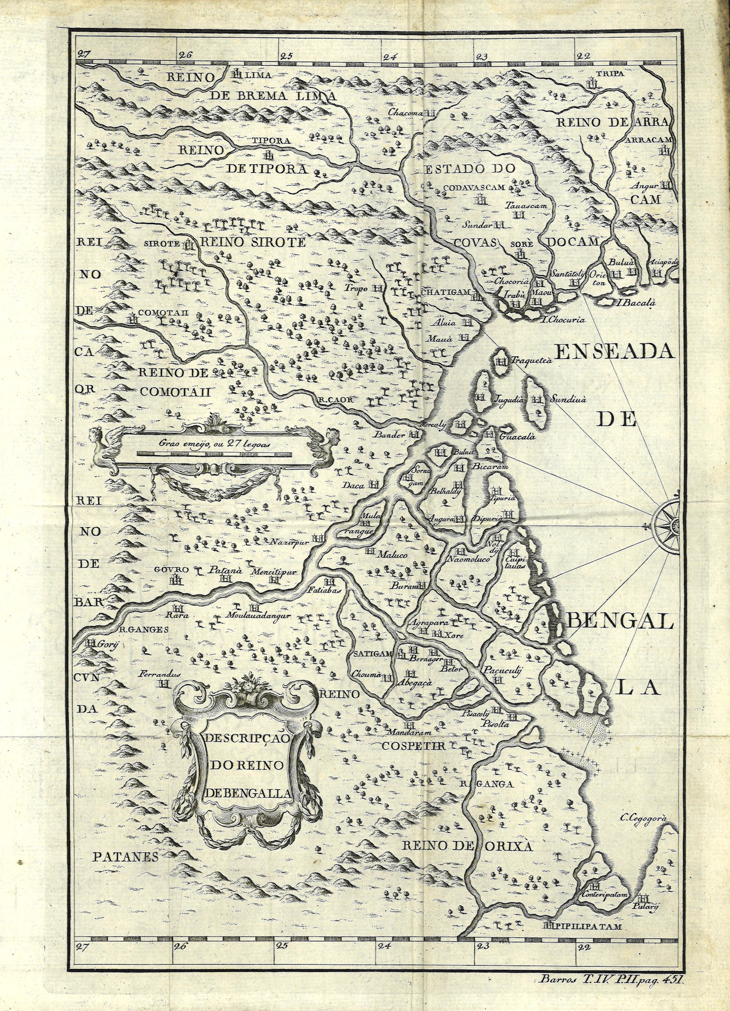
"Decadas da Asia" by Joao de Barros (1496-1570), is an epic historical account of the discoveries and conquests of the Portuguese in Asia, Africa and Brazil in the early 16th century. The 4th volume of this work, "Decadas Quarta da Asia", was published posthumously in 1615 with this map of the Kingdom of Bengal. The geographical information of this map dates from the period 1525-1535 CE. De Barros’ work was continued by another historian Diogo do Couto, who actually lived in Portuguese India for a decade between 1559 and 1569.
Descripcao do Reino de Bengalla is a foundational map of Bengal because of its level of detail. This map served as the template for future European maps of the region and no major changes were to be made for over a century. In looking at this map one must appreciate the difficulties faced by the cartographer where no surveys or astronomical observations of coordinates were made, distances and directions were only approximations and information was sometimes totally erroneous.
The map is east oriented, meaning east is up. Although the first print of this map is from 1615, the information for this map dates from approximately 1525 to 1550. The place names have been distorted by Portuguese adaptations and many are no longer recognizable.
Following is a list of countries at the border of Bengal:
Reino de Orixa: Kingdom of Orissa.
Reino Cospetir: Kingdom of Orissa. Cospetir is a corruption of Gajpati (Lord of the Elephants), the ruling dynasty of Reino Orissa.
Patanes: Pathan (Afghan) rulers of Bihar.
Reino de Barcunda: Bir Rajah’s of Birbhum.
Reino de Caor: Kingdom of Gaur. Northern Sylhet region. Annexed into Bengal 2 centuries prior.
Reino Sirote: Kingdom of Sylhet. Not actually a kingdom at this time but part of Bengal.
Reino de Comotaii: Kamata Kingdom of Assam
Reino de Brema Lima: Kachari Kingdom of Assam
Reino de Tipora: Kingdom of Tripura
Estado do Codovascam: Fiefdom of Khuda Baksh Khan, vassal to the Bengal Sultan.
Reino de Arracam: Kingdom of Arakan.
Following is a description of some cities in Bengal:
Gouro (Gaur) was the capital of Bengal in the early 1500’s. The ruins of Gaur are now located in Maldah district of West Bengal and an anonymous Portuguese writer’s account from 1521 describes it as “…very big, stretching for four leagues along the river and, it is said, extending so far inland that houses are still found beyond six leagues…The town is situated on a large plan which is flat like the whole of the surrounding area. The streets and lanes are paved like the Lisbon New Street. The market is everywhere and everything, food and other goods alike, is in plentiful supply and very cheap. The streets and cross-lanes are so full of people that that it is impossible to move and it has reached the point where the high noblemen have taken to being preceded along the road to the palace by men carrying bamboo sticks to push people out of the way.”
At Fatiabaz the Ganges bifurcates. The Hooghly-Bhagirathi channel flows south. Bernager (Baranagar) and Betor (Shibpur) are now part of greater Kolkata. The original village of Kalikata ( not shown in this map) would have been across the river from Betor. Fatiabaz represents Fatehabad or moder day Faridpur in Bangladesh and should be further east on the Padma River
This map was from around the time that the flow of the Ganges changed and the Padma branch flowing east became the main channel. De Barros mistakenly shows Daca (Dhaka) on the Padma River. At this time Dhaka was a minor town on the Buriganga River. Sornagam (Sonargaon) is shown as an island.
Near the Sunderbans coast we have a town called Cuipitavaz; this is a Portuguese corruption of Khalifatabad, now called Bagerhat in Bangladesh. It was established by the warrior-saint Ulug Khan Jahan Ali. The mosque and shrine complex initiated by him is a testament to the Bengal adaptation of Indo-Islamic architecture and is now a designated UNESCO world heritage site.
Further east are the island of Sundiua (Sandwip), the port of Chatigam (Chittagong) and Chacomas (Chakma Kingdom) of the Chittagong Hill Tracts.