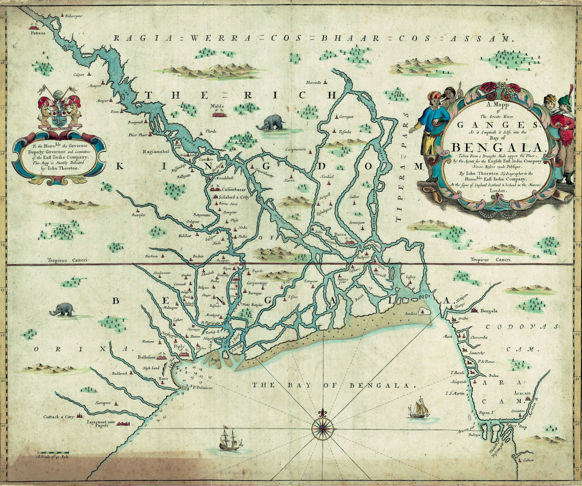
A MAPP OF THE GREATE RIVER GANGES AS IT EMPTIETH IT SELFE INTO THE BAY OF BENGALA
The English Pilot the Third Book was the first complete mariners guide and set of charts for navigating the Indian Ocean Area and the Far East. It was issued by English cartographer John Thornton in 1703 and then reissued in several more editions by other publishers. This map of Bengal is one of 35 charts included in the 1703 edition.
The East India Company (EIC) was at this time over a century old but two factors in the last quarter of the 17th century generated interest in the hydrographic mapping of India. First the entrenchment of EIC commercial bases in Madras (1640), Bombay (1668) and Hugli in Bengal (1651); Second the effort of an enterprising group of London Publishers who wanted to challenge the Dutch monopoly of the trade of printed maps and charts. Pioneer among this group was John Seller (1632-1697). It was Seller who came up with the idea of The English Pilot in four books where Book 3 would be dedicated to the oriental navigation.
There were several published issues of The English Pilot with this particular copy of the Thornton map included. However in cartographic style and execution this map is very different from the other maps in this book; also whereas all the other maps are accompanied by detailed accompanying text, no such text accompanies this map. Another distinction is that unlike other maps of The English Pilot, this particular specimen has contemporary color. All this is evidence that this map was not taken from the 1703 or later edition but most likely a precursor map.
This map is not dated. John Seller did make an attempt to publish the Third Book in 1675. Four fragmentary copies of this have survived, but these seem to be custom made collated editions with a different set of maps and charts in each example. One of the surviving copies from 1675 includes this map of Bengal. The cartouche and dedications are identical; however there is an additional inscription “Collected by John Seller, Hydrographer to the King”. Seller had financial difficulties and entered into a partnership with John Thornton and in 1679 bequeathed some of his engraved plates to Thornton. This particular map specimen probably dates to the early 1680’s.
Now coming to the map itself: John Thornton the mapmaker describes himself as Hydrographer to the Hono:ble East India Company” and dedicates the map “To The Hono:ble Govornor, Deputy Govornor and Committees of the East India Company”. The EIC archives do not mention Thornton as an official hydrographer but there is ample evidence that The Third Book was produced with official patronage of the East India Company.
The cartouche of the map states: “Taken From a Draught Made uppon the place by the Agents for the English East India Company Never Before made Publique”. This is probably not an accurate depiction. A comparison of the Thornton map with the Van den Broucke map shows the geographical outline of the two to be almost identical. The Dutch map was based on a maritime survey by naval commander Johan van Leenen in 1666-1667 but not published until 1726. It is therefore reasonable to assume that the Thornton map was derived from the Van den Broucke map.
The geographical names in the Dutch maps are more numerous and there are only 3 additional names on the English map which do not appear on the Dutch map (Id. Rogues, Nutte Banglar and Phier Phier). A more detailed record of the geographical features is given on the page on the Van den Broucke map.
This is probably the earliest British printed map dedicated to Bengal. The importance of this province to the East India Company is marked by the bold labeling “The Rich Kingdom of Bengala” printed across the map. This particular map is exceedingly rare. Besides this copy, three other copies are known to exist: in the British National Maritime Museum, British Library and the Bibliotheque Nationale de France.