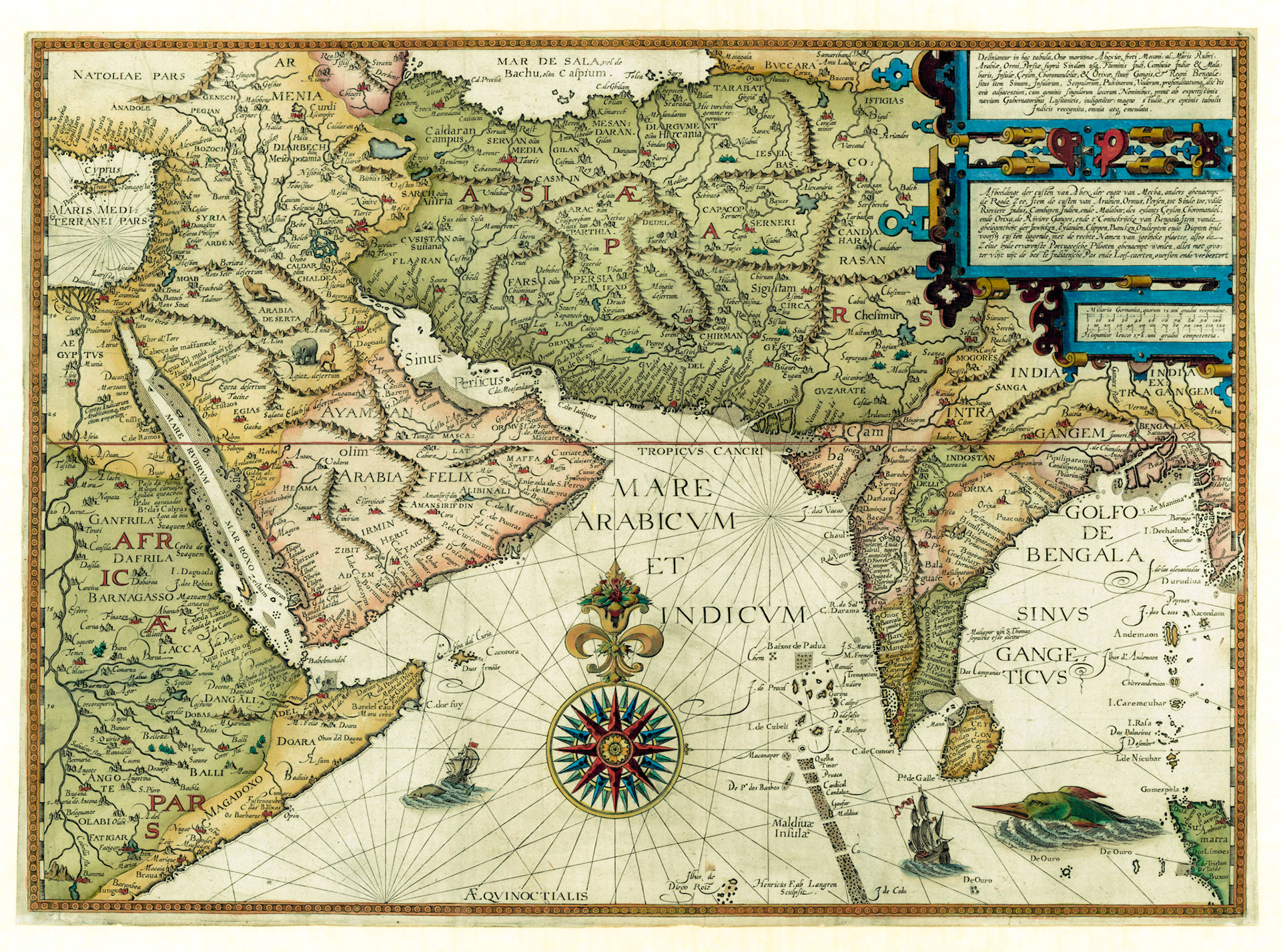
DELINIANTUR IN HAC TABULA, ORAE MARITIMAE ABEXIAE...MARIS ARABICAE...PERSIAE...INDIAE MALABARIS...CHOROMANDALIAE & ORIXAE...REGNI BENGALE...
This spectacular map was published in Amsterdam in 1596 as part of Jan Huyghen van Linschoten’s monumental work: The Itinerario. Fewer books have had as great an impact on changing the course of world history. The Itinerario removed the veil of secrecy surrounding the operations of the Portuguese trading empire in Asia. It paved the way for the Dutch and English to break the maritime trade monopoly of Portugal in the East and in course build their own colonial empires.
The map is centered on the Arabian Sea with Bengal in the east. The coastal outline of this 420 year old map looks almost like a modern map, unlike other maps of this period. The map is decorated in a lavish style with an exquisitely detailed compass rose, sailing ships, sea monsters and exotic animals. The quality of the engravings is a testament to the mastery of Dutch cartographers and engravers.
For most of the 16th century the maritime trade between Asia and Europe was dominated by the Kingdom of Portugal. The Portuguese “ Estado da India” was a network of trading posts and fortified positions along the Indian Ocean coast. It was a single administrative unit with its capital in Goa, headed by a Governor General. The Archbishop of Goa was the Roman Catholic primate of Asia. Every year a fleet of ships called the Portuguese India Armada would depart Lisbon and take the Cape of Good Hope route to Goa. They would return with spices and textiles which fetched a high price in European markets. From Lisbon a significant portion of the goods were picked up by the Dutch merchant fleet and marketed in Northern Europe.
This Portuguese-Dutch partnership worked well until two back to back events cut off Netherlands from the Asian trade. In 1580 a succession crisis in Portugal resulted in a dynastic union with Spanish crown. In 1581 Netherlands, which was then a part of the Spanish Empire, declared independence. Spain promptly blocked Dutch ships from trading with Lisbon.
In 1583 Jan Huyghen van Linschoten obtained a post as secretary to the Archbishop of Goa and traveled to India. During his 5 year stay in Goa he collected information from sailors and administrators about the people and the places that Portugal traded with. He also gained access to the top secret “roteiros”, navigational route maps executed in minute detail and continuously updated.
The effect of the publication of the Itinerario was far reaching. Within a short period Dutch merchant ships started arriving in Asia. The Dutch-Portuguese war started in 1602. Within the next few decades the Portuguese trading empire was gradually dismantled.
Linschoten never went to Bengal. In this map, Bengal correctly includes parts of modern Bihar and Orissa, but mistakenly includes parts of Myanmar. The major trading ports for the Portuguese were Satgaon in West Bengal and Chittagong in Bangladesh. In the text of the Itinerario it is mentioned that in Bengal the Portuguese have no forts, no government and no patrol ships, differentiating it from other coastal areas of the Indian Ocean. The two cities adjacent to Chittagong, Cituala (Chattala: Arakanese) and Bengala (Bangalah: Arabic) are alternative names of Chittagong used by seafarers from different eras but were still in use at this time. They were not separate cities.