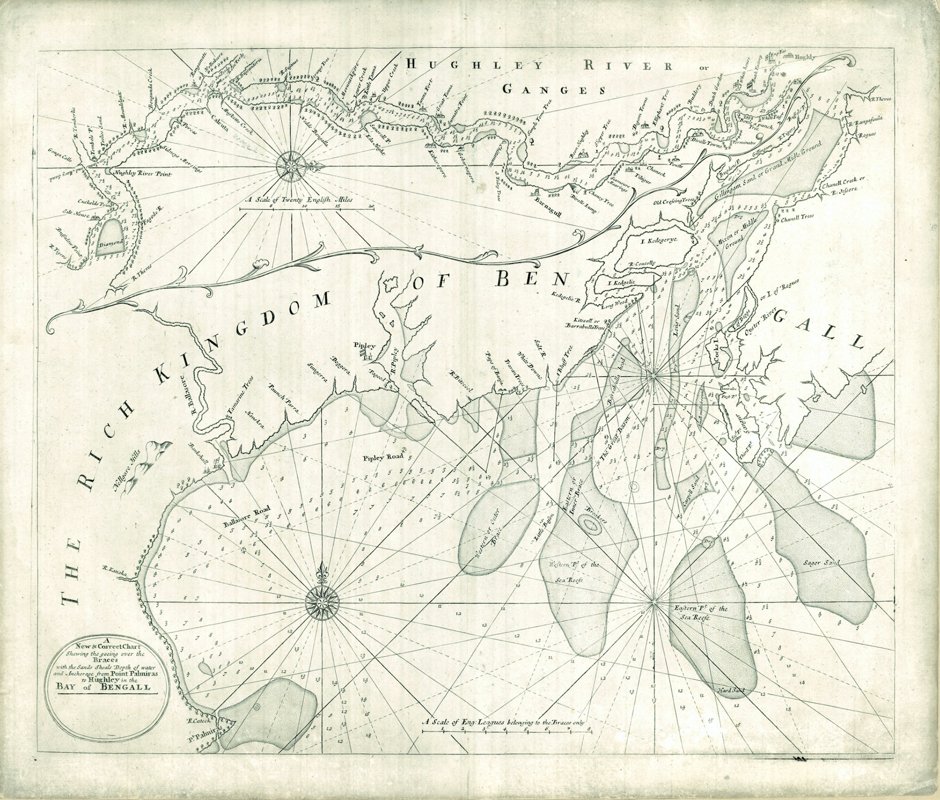
A NEW AND CORRECT CHART SHEWING THE THE GOEING OVER THE BRACES WITH THE SANDS SHOALS DEPTH OF WATERAND ANCHORAGE FROM POINT PALMIRAS TO HUGHLEY IN THE BAY OF BENGALL
Towards the end of the 17th century Portuguese domination of the European trade with Bengal had waned. The main contenders for this lucrative trade channel were now the Dutch and the British East India Companies. The most important trading port at this time was the inland port of Hugli on the Hooghly River.
In 1703 English cartographer John Thornton published “The English Pilot: The Third Book”. This was the first seaman’s guide and set of navigational charts of the Indian Ocean and the Far East, to be published in England. In 1711, after his death, his son Samuel Thornton reissued the book. The navigational chart of the Hooghly River shown here bears his imprint.
The English factory at Hugli port was established in 1651. Country boats from this factory would be loaded with goods and to form a convoy led by a small English pilot vessel called “The Transport”. The convoy would go down the Hooghly River and load the goods on to waiting ships of the East India Company anchored off Balasore (Baleshwar, Orissa). This was the beginning of the “Bengal Pilot Service”.
The English Pilots gained great experience in navigating the Hooghly River by guiding these convoys. In 1672 the pilots guided the ship “Rebecca”, which became the first East Indiaman to sail up the Hooghly River to the port of Hugli.
The men of the Bengal Pilot Service were instrumental in gathering and mapping the detailed navigational information which was used in making this chart. The chart has two parts: the lower part is the Hooghly River estuary and the upper part with west on top orientation shows the lower Hooghly valley as far north as the port of Hugli.
A glimpse at the lower chart shows an abundance of shoals and reefs with narrow passageways in between. This made navigation by oceangoing sailing ships up the Hooghly River very difficult. Water depths or soundings are shown in fathoms (1 fathom=6 ft=1.8 m). Two routes are described in the text of the English Pilot: one through the passages called Balasore Road and Pipley Road and then over the Eastern and Western Braces; the second route between Sagor Sand and the Eastern Part of the Sea Reef.
The upper chart is an illustration from the chapter in the book entitled “Mr Herring, the Pilots Direction of bring of ships down the River of Hughley”. On the upper right hand is the port of Hugli and the factories of the British, Dutch and Danish are shown with their respective flags. Shoals on the river are identified by landmarks in the banks such as large trees or temples. This chart was made before the British acquisition of Calcutta. The villages of Sutanuti (Chittanutti) and Gobindapur (Governapore) appear on the east bank of the river. However Kalikata (Kolkata) which is situated between these two is not marked.