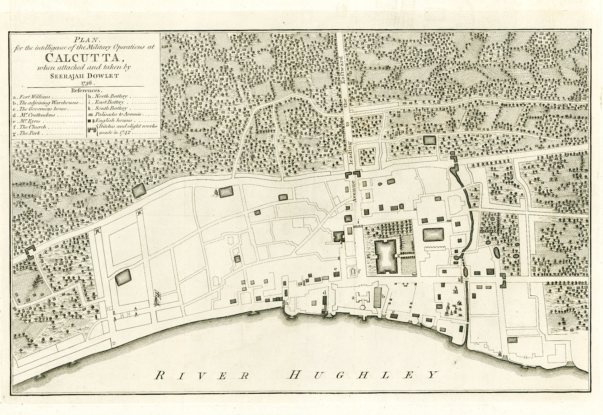
PLAN FOR THE INTELLIGENCE OF THE MILITARY OPERATIONS AT CALCUTTA WHEN ATTACKED AND TAKEN BY SEERAJAH DOWLET 1756
Fort William in the modern city of Kolkata is the headquarters of the Eastern Command of the Indian Army. It was built by Colonel Robert Clive after the Battle of Plassey (1757) and the British settlement of Calcutta grew around it. The original Fort William, now referred to as “Old Fort William” was a totally different structure north of the current fort.
For most of the 17th century the commercial interests of the East India Company (EIC) was managed from Fort St. George in Madras (Chennai). As the Bengal trade expanded the directors of the EIC created a separate agency for Bengal and in 1682, appointed one of their own, William Hedges, to become the first Chief Agent of Bengal. It was Hedges’ idea to build a fortified port close to the mouth of the Hooghly River to protect British interests from other European powers as well as from subordinates of the Nawab of Bengal. In 1690 the Chief Agent of Bengal, Job Charnock built an unauthorized settlement in Sutanuti and called it Calcutta after the nearby village of Kalikata. In 1696 when Charles Eyre was Chief Agent of the EIC in Calcutta, the authorization for transfer of the Jagirdari (Tenancy) of the villages of Sutanuti, Kalikata and Govindapur was obtained from Prince Azim-us-Shan, the Governor of Bengal and grandson of Emperor Aurangzeb. In 1699 the EIC declared Bengal as a separate Presidency and named the fort to be built in Calcutta as Fort William after the then British monarch William III.
This plan is that of the Old Fort William as it existed in 1756. The map is oriented east (north is to the left). The site of the fort is marked with the letter a. The outline of the fort is an irregular rectangle. The east face fronting the river extended 700 feet. The north face ran inland for 310 feet and south face 500 feet. There was a bastion in each corner to provide flanking fire, here shown as conical projections. Inside the walls was the imposing Factory or Government house, the armory, storage facilities and the clerks’ quarters. The main entrance was to the landward side. Three principal avenues led out of this entrance, at the end of each was an artillery battery. On the river side the rear entrance led to the Ghats or landing places.
If we project this map into modern Kolkata the fort would be in the area of Dalhousie Square between Fairlie Place in the north and BTM Sarani in the south. There is a brass line on the steps of the Kolkata GPO marking the southeast bastion of the fort. The large lake east of the fort is now called Lal Dighi. St. Anne’s church marked f, the first Anglican church of Kolkata, stood at the site of the Writers Building.
Calcutta in 1756 was a segregated city. The shaded habitations in this map are marked as English Houses. This section of the town was called the European Town but colloquially as the White Town. Besides the English it housed large numbers of people of Portuguese, Armenian and Eurasian descent. The Indian merchants lived in the Black Town north of the fort whereas the Indians of lower socioeconomic class lived towards the south.
Old Fort William was functional between 1700 and 1756. The Bengal Army led by Nawab Sirajud Daula attacked and laid siege to the fort and the British surrendered on June 20, 1756. After the victory of Clive over the Nawab in the battle of Plassey in 1757, Old Fort William was abandoned.