In the first half of the 17th century, Dutch and Flemish mapmakers were at the forefront of European cartography. They made maps which incorporated the most recent geographical information, but what sets these maps apart are the rich decorative elements and the magnificent presentation. European mapmaking was elevated into an art form.
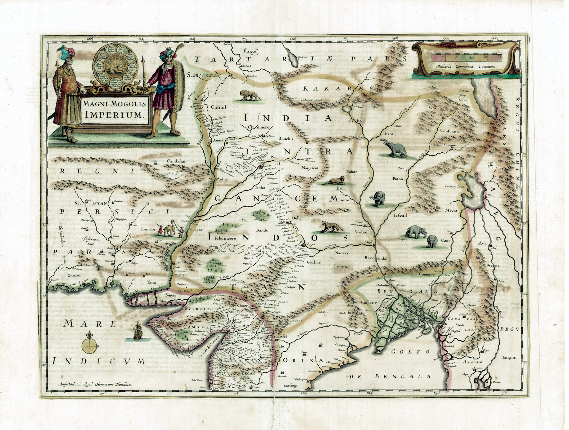
Henricus Hondius was a member of the extended Hondius family of this Dutch school of cartographers. This map is his version of the Mughal Empire. On the upper left corner the cartouche shows the Lion and Sun Mughal standard. Surrounding it is the genealogical lineage of the Mughal Emperors, starting with Temur (Tamerlane) going clockwise and ending with Jahangir at the bottom. At the time of printing of this map Jahangir was dead for over a decade and Shahjahan was the new emperor. Flanking the standard are two officials in full Mughal regalia.
Hondius’ map of the Mughal Empire is based on the Baffin-Roe map with more information added. In western India we see details of the way-stations on the caravan route: Surat-Agra-Delhi-Lahore-Kabul. Another route is shown from Agra to Jaisalmer across the Rajasthan Desert. Hondius’ Bengal is very different from that of the Baffin-Roe map, for what he has done here is taken the De Barros map of Bengal in its entirety and placed it here.
The names of some of the cities in Bengal can be identified while others are placed far from where they should be. On the Arakan coast we see Bacala and Bulua. Bacala is Bakla the old name of Barisal and Bulua is Bhulua the old name of Noakhali in Bangladesh. They are actually situated on either side of the mouth of the Meghna River.
Hondius’ map shows elephants roaming the countryside. Wild elephants were plentiful in Bengal and since ancient times were domesticated and used as instruments of war. The Baharistan-i-Ghaybi , a chronicle of the Mughal wars in Bengal , written by an officer in the Mughal Army named Mirza Nathan, details a “ Kheda Operation”. This is an elaborate operation to corral wild elephants into a prebuilt enclosure called a “Kheda”. Mirza Nathan narrates: “Iftikhar Khan, Mubariz Khan and Raja Satrajit wrote that they had brought a large number of elephants to the “Qamargah” (ring-hunt). Therefore, Islam Khan marched quickly and reached early in the morning a place at a distance of five kos from Nazirpur where the elephants were decoyed to the hunting enclosure. They began the game of kheda and captured one hundred and thirty-five elephants by trapping them in the khad (ditch), and tied them to the noose of trained hunting elephants”.
Nazirpur mentioned in the above narrative can be identified in this map. A city of some significance in the early Mughal era, Nazirpur is now a small township in the western suburb of Pabna City in Bangladesh.