The defeat of Siraj ud-Daula, Nawab of Bengal, in the Battle of Plassey of 1757, brought to an end over 550 years of almost continuous rule by Muslim sovereigns over a largely non-Muslim population. The British victory did not go unchallenged. However Robert Clive tackled each challenge both European and Indian with ruthless efficiency. In 1765 the hapless Mughal Emperor Shah Alam II, in an act of appeasement, offered the East India Company (EIC) the Diwani (Right to collect taxes) of Bengal. British colonial rule in Bengal had begun.
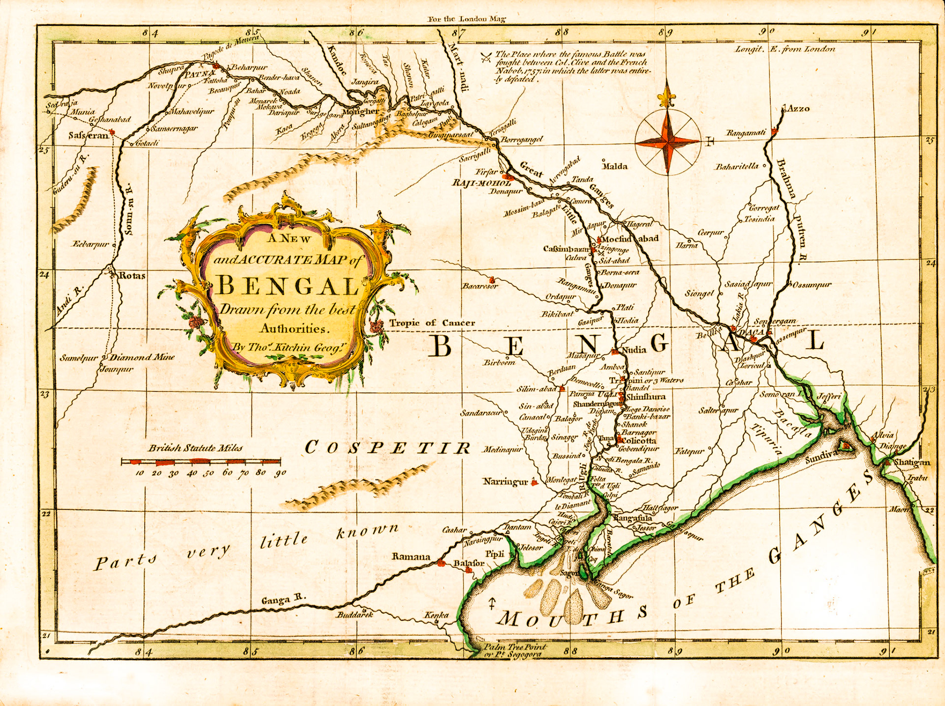
“A new and accurate map of Bengal” by Thomas Kitchin, published just over 2 years after the Battle of Plassey contains many inaccuracies. The site of the battle marked by crossed swords is wrongly positioned at Cassimbazar about 20 miles north of Plassey which is labeled “Plati”. Siraj ud-Daula is referred to as the “French Nabob”. For the British following the war from afar this battle was an extension of the Anglo-French Seven Year War being fought in 4 continents.
This map is a good study of the hydrography of Bengal of the period. Since ancient times the main flow of the Ganges in Bengal has been through the Bhagirathi-Hooghly channel (Hooghly River) which empties into the Bay of Bengal. In Hinduism the Ganges is a sacred river personified as the goddess Ganga, it is associated with life and fertility and bathing in its waters offers ritual purification. The cult of Ganga is of deep antiquity and its banks are dotted with cities with sacred sites of pilgrimage. Tribeni (Tripini or 3 waters in this map) is one of these cities. Here the Ganges at one time split into 3 branches. From West to East these were the Saraswati, the Ganga (Adi-Ganga, Hooghly) and the Jamuna. Sometime in the 16th century the Ganges changed course and started flowing along the Padma branch towards Eastern Bengal. So in this 18th century map the Hooghly is called the Lesser Ganges and Padma the Greater Ganges. At Tribeni the Jamuna went dry. The Saraswati still existed as a navigable channel, here labeled the Juan Pardo River, obviously a Portuguese appellation.
Another interesting feature in this map: In the South there is a river flowing west to east called the Ganga River. Two Ganga Rivers in the same map!! Well this second one is a major cartographic error. This river entered the European Cartographic record in the 1500’s and got copied into most maps until the late 1700’s. The explanation probably lies in the inscription above the river: “Parts very little known”.