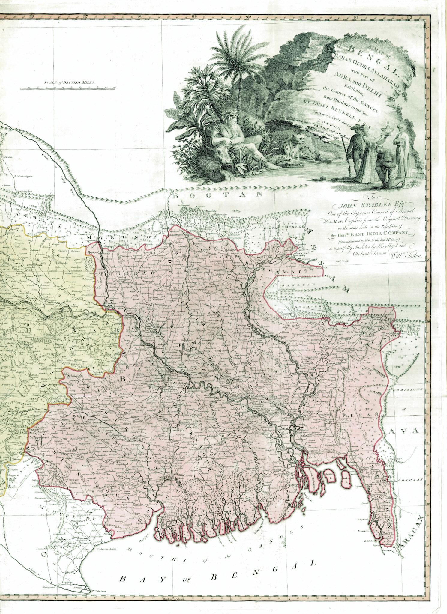
A MAP OF BENGAL, BAHAR, OUDE &ALLAHABAD WITH PART OF AGRA AND DELHI EXHIBITINGTHE COURSE OF THE GANGES FROM HURDWAR TO THE SEA
On August 12, 1765, the Treaty of Allahabad was signed between the Mughal Emperor Shah Alam II and Robert Clive of the East India Company (EIC). A series of military defeats sustained by the Mughal Forces starting with the Battle of Plassey in 1757 and ending with the Battle of Buxar in 1764 culminated in this treaty. The treaty gave the EIC the Diwani Rights (authority to collect revenue) in the provinces of Bengal, Bihar and Orissa, in return for an annual tribute to the Emperor of 26 lakh Rupees. Bengal would technically still be a Mughal province, ruled by a titular Nawab; however administrative, commercial and economic power now rested on the East India Company.
The East India Company proceeded to consolidate its power in Bengal by systematically dismantling the existing administrative, judicial and military infrastructure. The EIC hired a young surveyor named James Rennell. Between 1764 and 1777, from his headquarters in Dhaka, Rennell surveyed most of the newly acquired territories. The surveys provided a utilitarian purpose by facilitating transportation of goods, collection of revenues and movement of troops. The maps that were drawn based on these surveys were however much more than utilitarian.
In this map printed for William Faden, royal geographer to King George III and based on Rennell’s surveys, the EIC controlled areas including Bengal are shown in pink and sharply demarcated. Pink would continue to be the map color of Company rule. The target audience for this map was British and other Europeans. This was an effort to establish the legitimacy of Company rule in Bengal. Notwithstanding the fact that the EIC was a publicly traded company based in London, the impression this map is trying to create is that: Bengal is a British overseas territory and the ultimate benefactors of company rule in Bengal were the British people. The map was also designed to send a signal to other European powers, clearly delineating what part of India belongs to Britain.
In the upper right of the map is a detailed cartouche. A River-God relaxes amidst lush vegetation with his foot dipping in the waters of the Ganges. He holds in his arms a sheaf of rice and rests his hand on a cow’s head. The allusion is to a Neptune-like figure holding a trident and the cow-head to Gomukh, the mythological source of the Ganges; a rock formation in the shape of a cow’s head from whose mouth the Ganges sprang forth. On the other side of the river there is a Hindu Brahmin in a kneeling submissive posture, a Muslim in Mughal attire with his right hand over his heart in a sign of reverence, a native soldier in the employ of the Company standing at ease with his rifle and a bejeweled lady lighting a lamp.
Since time immemorial the Ganges River has been personified as a female deity: Maa Ganga. The image of the Greco-Roman God is a message that a great change has happened in Bengal with Indian femininity being replaced with European masculinity, a change as much celestial as it is terrestrial. The people of Bengal are depicted as welcoming this change and the lady with the lamp personifies a new light where darkness existed. Nothing, however, could be farther from the truth. Company rule in Bengal was designed for economic exploitation and the great famine of Bengal of 1770, which started within 5 years of the beginning of Company rule, resulted in an estimated loss of 10 million lives. The EIC had to deal with one rebellion after another and in one of these, The Fakir-Sannyasi Rebellion, James Rennell himself was severely injured and came close to death.
This map ultimately is about power, about possession and about creating a legitimacy of territorial control.