In the scale of ferocious battles waged on the plains of Bengal, the Battle of Plassey would rank as a minor conflict. However what happened that fateful day of June 23, 1757, on a rain soaked field outside the small town of Plassey would change the fortunes of Great Britain as a nation and also the peoples of Bengal and the wider Indian Subcontinent.
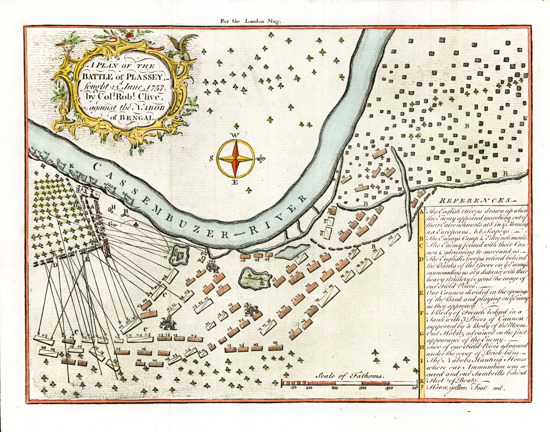
This battle plan was published in the London Magazine less than 3 years after the actual battle. The compass rose tells us that the map has a West orientation, meaning North is to the right. The Cossimbazar River is actually the Bhagirathi River a distributary of the Ganges. The arrow on the river shows its North-South flow. Murshidabad the capital of Bengal is about 30 miles (50km) upstream; Calcutta the English settlement is about 100 miles (160 km) downstream. The town of Plassey is immediately to the left.
The protagonists in the battle were Lieutenant Colonel Robert Clive, leading the British forces and Siraj-ud-Dowla, Nawab of Bengal, leading the Bengal Army. The French who were allied to the Nawab sent a small contingent to fight alongside the Bengalis.
In the frontline of the Bengal Forces were the Generals Mir Madan and Mohan Lal ; fiercely loyal to the Nawab their troops formed the vanguard and were closest to the river. Three other columns led by Rai Durlabh, Yar Latif Khan and Commander in Chief Mir Jafar in that order fanned out away from the river to outflank the British. However in a historical act of treachery, Mir Jafar and his two cohorts had conspired with Robert Clive to stand down and hold their fire at the height of the battle, on condition that if the British won then Mir Jafar would be crowned Nawab of Bengal. The battle plan shows 3 war elephants. The Bengal Army had a powerful cavalry that the British completely lacked. On the Bengal frontline, close to the river is seen a water tank; this is where the French artillery unit led by M. de Sinfray was stationed. The Nawab remained in his camp (upper right) throughout the battle.
The British Forces included officers and men of both the East India Company (EIC) and the Royal Army (HM 39th Foot). The rank and file included many Eurasians and native Indian troops under the employ of the EIC. The British had their backs against a large mango grove on the left side of the battle field. This allowed them to retreat out of sight in the face of artillery and counterattack. The ships of the Royal Navy which transported the British upriver from Calcutta can be seen moored on the bank of the river. There is a rectangular structure in the angle between the mango grove and the river bank. This is the Nawab’s hunting lodge. It was occupied by the British the day before the battle and Clive observed the battle unfold from its rooftop.
In the end it was a famous victory for Robert Clive and the British against a numerically superior Bengal Army. It was achieved partly by superior technology and military tactics but mainly by a conspiracy involving Siraj-ud-Dowla’s inner circle. In less than a decade after the battle the British would become overlords of Bengal and set the stage for the conquest of India. For the Bengalis the battle is remembered as an epic tragedy and the ensuing period is remembered in an oft repeated refrain: “The two hundred years of servitude”.