SINUS GANGETICUS; VULGO GOLFO DE BENGALA. NOVA DESCRIPTIO
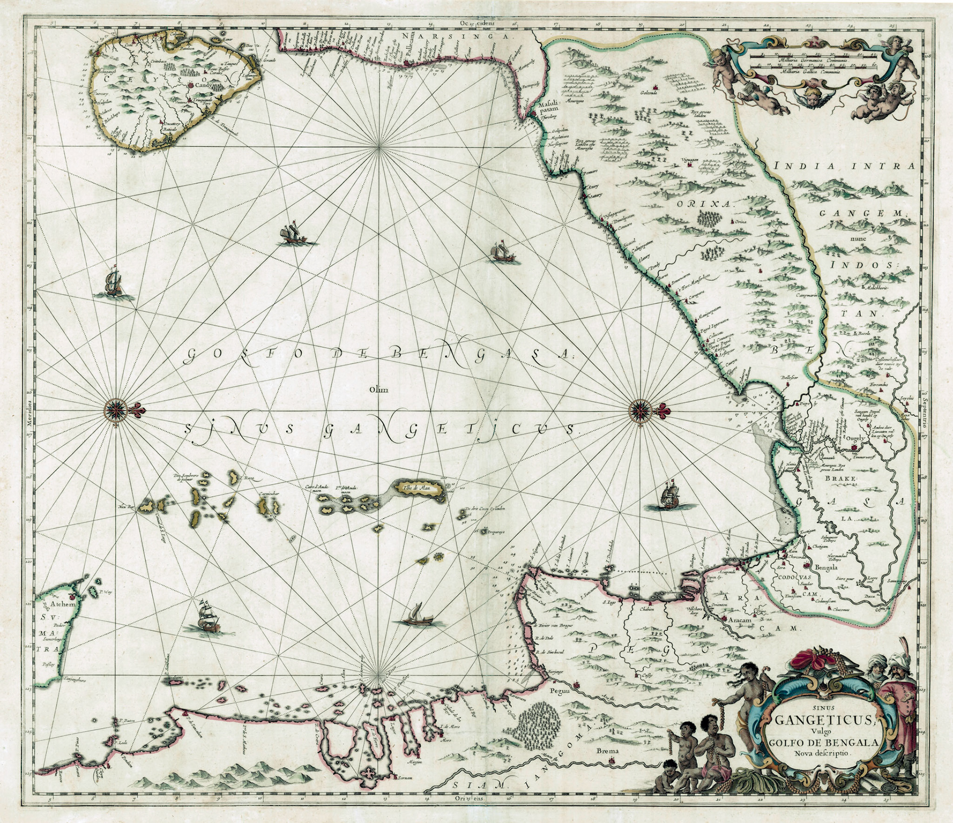
A magnificent decorative map of the Bay of Bengal coast by Dutch mapmaker Jan Jannson. The map has a west orientation (west is up) and extends in a sweeping arc from Ceylon to Sumatra. Sailing ships ply the bay which is criss-crossed by rhumb lines. This map is taken from the 5th volume of Jan Jannson’s Atlantis Maioris published in 1650. This volume was named Water Wereld (Water World) and was one of the earliest sea atlases.
The Ganges River is shown on the right. It splits into two branches; one going towards Hooghly (Ougely) and the other towards Dhaka (Dacca). There are many inscriptions near the Hooghly River on this map which point towards the importance the Dutch put into this region as they tried to wrest control of the Bengal-Europe trad
A magnificent decorative map of the Bay of Bengal coast by Dutch mapmaker Jan Jannson. The map has a west orientation (west is up) and extends in a sweeping arc from Ceylon to Sumatra. Sailing ships ply the bay which is criss-crossed by rhumb lines. This map is taken from the 5th volume of Jan Jannson’s Atlantis Maioris published in 1650. This volume was named Water Wereld (Water World) and was one of the earliest sea atlases.
The Ganges River is shown on the right. It splits into two branches; one going towards Hooghly (Ougely) and the other towards Dhaka (Dacca). There are many inscriptions near the Hooghly River on this map which point towards the importance the Dutch put into this region as they tried to wrest control of the Bengal-Europe trade from the Portuguese. The port of Hooghly was described by the Dutch as “…the most suitable place for trade in all of Bengal”. The goods the Dutch coveted were raw silk, textiles, sugar, rice, clarified butter and saltpeter which was used to make gunpowder. Not all of the goods were destined for Holland, because the Dutch were also involved in the intra-Asian trade stretching from Persia to Indonesia. A slave trade also existed where Bengali slaves were shipped to Indonesia to secure and develop the new Dutch colony.
At this early age of the Dutch foray into the Bengal trade we can see that the map contains numerous errors especially in the interior of Bengal. Kasim Bazar, famous for its raw silk, as the inscription says is placed well above the bifurcation of the Ganges. Chittagong City is placed in three locations (Exettigam, Chatigam and Bengala city). One also gets the impression that it is possible to reach Dhaka by going up the Karnaphuli River, here named the Cosmin River.
One remarkable feature of this map is a river route going from the Hooghly estuary across the Sunderbans forest towards Dhaka, where the finest muslin cloth was produced. There are two toll houses (tolhuys) marked on this channel. According to the Mughal authorities the Dutch would pay custom duties at the port but were exempt from transit duties. The transit toll was exacted by local Zamindar’s and tributary Rajah’s and the Mughal authorities turned a blind eye to this infraction.
A final note: this is the earliest printed map to show St. Martins Island of Bangladesh. Originally named by the Portuguese, this is a small coral island which is the southernmost point of Bangladesh and now a major tourist destination.
e from the Portuguese. The port of Hooghly was described by the Dutch as “…the most suitable place for trade in all of Bengal”. The goods the Dutch coveted were raw silk, textiles, sugar, rice, clarified butter and saltpeter which was used to make gunpowder. Not all of the goods were destined for Holland, because the Dutch were also involved in the intra-Asian trade stretching from Persia to Indonesia. A slave trade also existed where Bengali slaves were shipped to Indonesia to secure and develop the new Dutch colony.At this early age of the Dutch foray into the Bengal trade we can see that the map contains numerous errors especially in the interior of Bengal. Kasim Bazar, famous for its raw silk, as the inscription says is placed well above the bifurcation of the Ganges. Chittagong City is placed in three locations (Exettigam, Chatigam and Bengala city). One also gets the impression that it is possible to reach Dhaka by going up the Karnaphuli River, here named the Cosmin River.
One remarkable feature of this map is a river route going from the Hooghly estuary across the Sunderbans forest towards Dhaka, where the finest muslin cloth was produced. There are two toll houses (tolhuys) marked on this channel. According to the Mughal authorities the Dutch would pay custom duties at the port but were exempt from transit duties. The transit toll was exacted by local Zamindar’s and tributary Rajah’s and the Mughal authorities turned a blind eye to this infraction.
A final note: this is the earliest printed map to show St. Martins Island of Bangladesh. Originally named by the Portuguese, this is a small coral island which is the southernmost point of Bangladesh and now a major tourist destination.