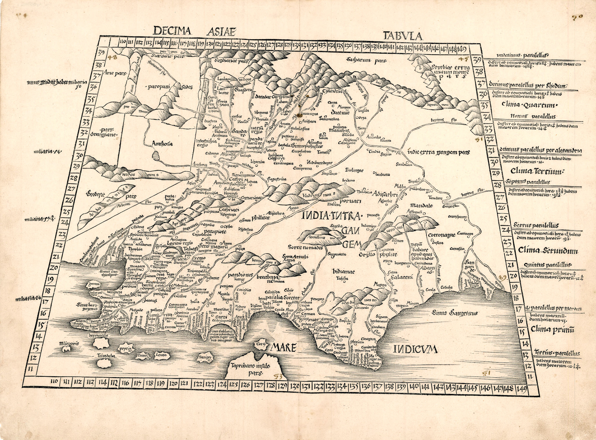
Ptolemy’s tenth map of Asia portrays South Asia and it looks nothing like the Indian Subcontinent we now know. The coastline is almost horizontal and most of the named geographical features are unrecognizable. What is remarkable though is the amount of geographic detail in this ancient map. Much scholarly work has been done on this map and it has been shown that many of the named cities and rivers do correspond to places found in Indian sources around the time of Ptolemy, circa 150 CE.
This map was printed in 1513 CE, more than 1300 years after Ptolemy and European geographical knowledge of India had progressed very little in the intervening period. This map was drawn by the German cartographer Martin Waldseemuller who was also drawing maps based on the new information being brought back by the Portuguese expeditions to India.
The Ganges River is to the right of this map. At its upper reaches it receives a tributary called the Diamouna River. This is the Jamuna River that now passes by the Tajmahal in Agra. Midway through the course of the Ganges is the city of Palibothra. This is Pataliputra (near Patna, Bihar), ancient capital of the Maurya Empire which once included Bengal.
Downstream from Palibothra is Tamalites. This is identified as modern Tamluk, about 70km SW of Kolkata. In contemporary Indian sources it is Tamralipti (Sanskrit) or Tamalitti (Pali). This was a seaport with vigorous maritime activity and Ptolemy erroneously places it far north of the coast. It was from this port, in the 3rd century BCE that Sanghamitra, daughter of Emperor Asoka sailed to Sri Lanka carrying a sapling of the Bodhi tree to spread the teachings of Buddha.
Ptolemy in his Geographia states “In the entire region about the mouth of the Ganges are the Gangaridae whose city is Ganges Regia”. Bengal represents in a general way the country of the Gangaridae. However a corresponding Indian name to Gangaridae does not appear in any ancient Indian text. The identity of Gange Regia, the presumed capital is unknown, although a strong contender is Chandraketugarh, an archeological site about 35 km NE of Kolkata.
Ptolemy names five specific mouths of the Ganges. From west to east Cambysum R, Magnum R, Camberycum R, Pseudostomum R, Antibola R. The distance between the two extreme mouths is 4 degrees longitude which is also the same distance between the mouth of the Hooghly and Padma rivers, the extreme mouths today. The hydrography of the Ganges delta region is in a continuous state of flux and so trying to identify corresponding modern rivers from this 2000 year old map is a matter of conjecture.
Ptolemy also mentions two other cities in Gangarida: Palura City and Tilogrammum City. The identities of these cities have not been established.