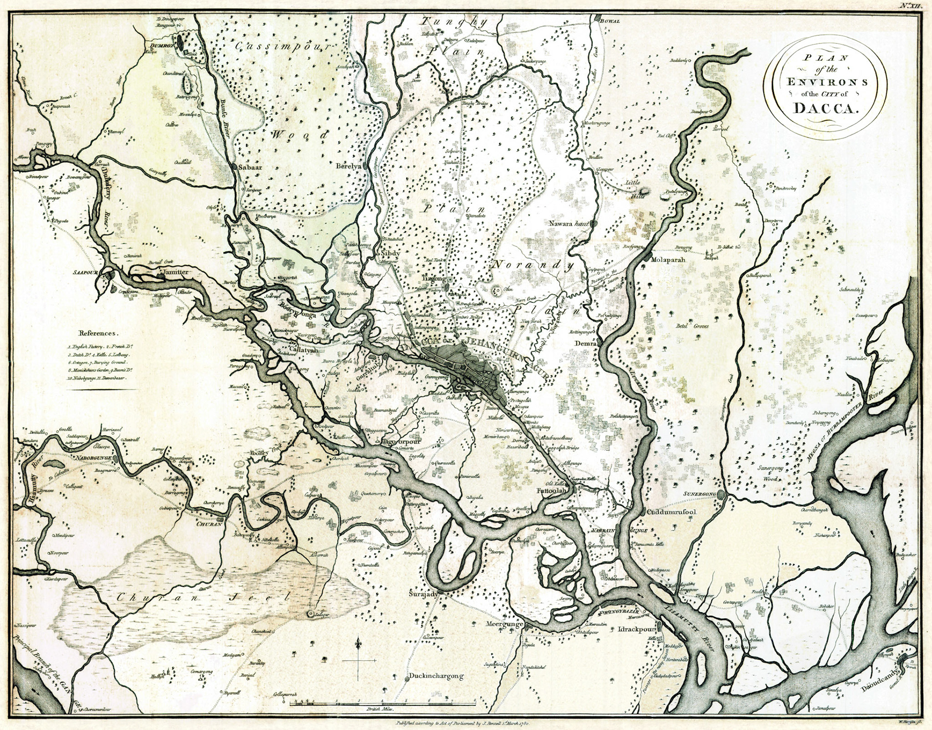
PLAN OF THE ENVIRONS OF THE CITY OF DACCA
In 1610, under Mughal rule, Dhaka became the capital of Bengal. Within a short period it was transformed from a sleepy township to a center of trade, politics, culture and military power. It reached its zenith during the governorship of Shaista Khan, Subahdar of Bengal, 1664-1688. The fortunes of Dhaka began to decline in the early 1700’s with a weakening of central Mughal rule and the transfer of the capital of Bengal to Murshidabad.
James Rennell was appointed the first Surveyor General of Bengal in 1764 by the East India Company (EIC), seven years after the Battle of Plassey. The next year, 1765 after the treaty of Allahabad, the EIC became the de facto ruling authority in Bengal. Rennell from his headquarters in Dhaka completed a comprehensive and systematic survey of Bengal and Bihar over a 13 year period. In 1780 his work was compiled and published in “A Bengal Atlas”. This map is one of the maps from the 1781 edition of this atlas.
The map is entitled “Dacca and its Environs”. Today 250 years later the limits of Dhaka has spread in all directions but mostly to north. The old city of Dhaka (Dacca or Jehanguirnagar) is shown as a shaded area. The neighborhoods and the streets are not named. From Dhaka a road goes northwards through Tejgaon (Tizgong) to Tongi (Tunghy Plains). This was a Mughal military road which connected Dhaka to North Bengal. The road passes through “Bose’s Garden”, probably a private estate in the Shahbagh-Ramna area. Then there is “Umber’s Bridge” and a mosque. The mosque still exists and is known as Khwaja Ambar Mosque in the Karwan Bazar neighborhood. The bridge has become part of Kazi Nazrul Islam Road. Both were constructed by the wealthy Khwaja Ambar, chief eunuch of Subahdar Shaista Khan. Further north are estates held by the Dutch, English and French. These were originally factories or trading posts of the respective European countries which were later moved to the old city. The church in this area is the Holy Rosary Church of Tejgaon. It was built by Portuguese missionaries and probably the earliest Christian house of worship in Dhaka.
From the western edge of the old city a road progresses northwards toward a mosque. This is the Sat Gambuj (Seven Domed) Mosque in Mohammadpur area and the road roughly corresponds to the present Satmasjid Road. Three localities: Jaffierabad (Zafrabad), Sultangunge(approximately Rayer Bazar area) and Innitpour (Enayetpur, approximately Hazaribagh area) are shown in the map. This is a testament to Mughal settlements extending westward along what was then the banks of the Buriganga River.
Two major water channels traversed Dhaka. The Dooli Creek (Dulai Canal) branched off the Balu River and took a southwesterly course towards Dhaka. It formed a network of canals in old Dhaka which was used for intra-city transport and commerce. A branch of the Dulai Canal shown as Nerri Creek in this map was known as the Pandu River to locals. This channel went directly east to join the Buriganga River. Rampura Khal, Hatir Jheel and Dhanmondi Lake are remnants of this water channel.
This map originally published in March 1, 1780 is the earliest detailed printed map of the Dhaka city area.