Fort William in the modern city of Kolkata is the headquarters of the Eastern Command of the Indian Army. It was built by Colonel Robert Clive after the Battle of Plassey (1757). The original Fort William, now referred to as “Old Fort William” was a totally different structure north of the current fort. This fort existed between 1700 and 1756 and was named after King William III, then King of England, better known as William of Orange. It was abandoned after the Battle of Plassey and replaced by the new fort.
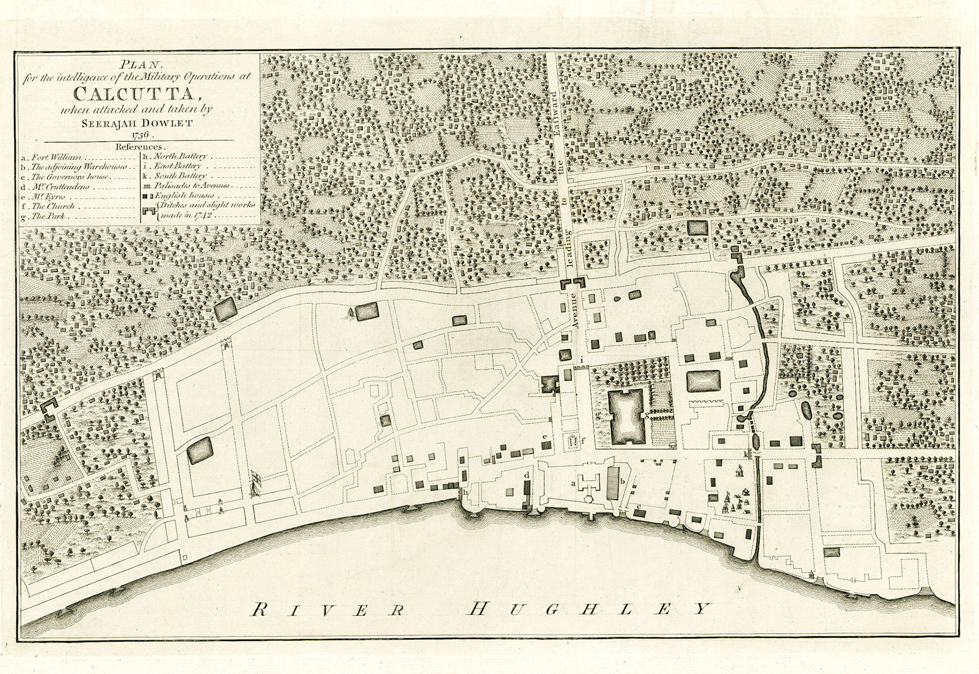
This plan is that of the Old Fort William as it existed in 1756, as the British faced the onslaught of the Bengal Army led by Nawab Sirajud Daula (spelled Seerajah Dowlet in this map). The map is oriented east (north is to the left). The site of the fort is marked with the letter a. The outline of the fort is an irregular rectangle. The east face fronting the river extended 700 feet. The north face ran inland for 310 feet and south face 500 feet. There was a bastion in each corner to provide flanking fire, here shown as conical projections. Inside the walls was the imposing Factory or Government house, the armory, storage facilities and the clerks’ quarters. The main entrance was to the landward side. Three principal avenues led out of this entrance, at the end of each was an artillery battery. On the river side the rear entrance led to the Ghats or landing places.
If we project this map into modern Kolkata the fort would be in the area of Dalhousie Square between Fairlie Place in the north and BTM Sarani in the south. There is a brass line on the steps of the Kolkata GPO marking the southeast bastion of the fort. The large lake east of the fort is now called Lal Dighi. St. Anne’s church marked f, the first Anglican church of Kolkata, stood at the site of the Writers Building.
Calcutta in 1756 was a segregated city. The shaded habitations in this map are marked as English Houses. This section of the town was called the European Town but colloquially as the White Town. Besides the English it housed large numbers of people of Portuguese, Armenian and Eurasian descent. The Indian merchants lived in the Black Town north of the fort whereas the Indians of lower socioeconomic class lived towards the south.
Paintings of Fort William during this period portray a formidable structure. However as a fort it had serious structural defects: the curtains were relatively thin, the bastions were small, and there was no moat. Also on 3 sides it was surrounded by buildings which would give cover to attacking forces and on the south side there was a covered warehouse abutting the fort wall which could allow any attacker taking over the warehouse to easily ram the southern wall. The East India Company was after all a company of merchants and not of soldiers. The artillery defenses of Old Fort William was not built to withstand a major armed incursion. There was also the strategic blunder of trying to defend the entire White Town resulting in heavy losses before the British retreated to the fort.
The attack, siege and surrender of Old Fort William by a numerically superior Bengal Army led by Nawab Sirajud Daula was swift. After 4 days of fighting the British surrendered on June 20, 1756.