CHART OF THE NORTHERN PART OF THE BAY OF BENGAL LAID DOWN CHIEFLY FROM THE SURVEYS MADE BY BARTHOLOMEW PLAISTED AND JOHN RITCHIE
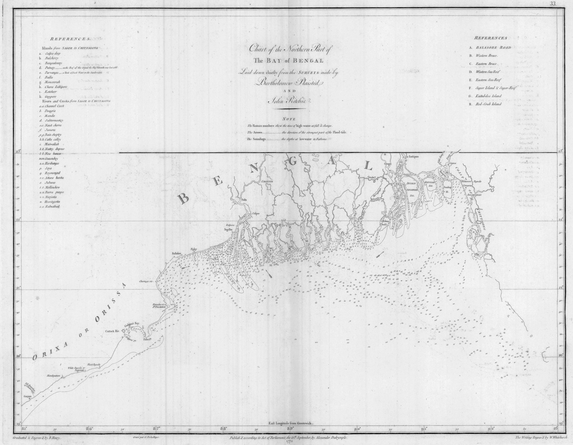
Alexander Dalrymple (1737-1808), a Scottish geographer, started a private publication of charts and plans with grants or subscriptions from the East India Company (EIC) in 1767. In 1779 he became official hydrographer of the EIC and in 1795, the first hydrographer of the British Admiralty.
In his 1772 publication “Memoirs of a Chart of the Bay of Bengal”, he writes: “It must appear very extraordinary, when it is considered how long the Europeans have had an intercourse with Bengal, that there is not hitherto a particular chart of the Bay of Bengal in any language”.
This chart published by Dalrymple in 1772 is based on surveys conducted by EIC marine surveyors Bartholomew Plaisted and John Ritchie. The chart shows sound depths in fathoms at low tides as well as the direction and times of high tides.
The chart with its accompanying navigational instructions was intended as a guide for British ships to enter the Hooghly and Karnaphuli Rivers to reach the ports of Calcutta and Islamabad (Chittagong) respectively. This chart for the first time shows a detailed survey of the Sunderbans coast. A Dutch map by Francois Valentijn from 1726 describes this coast as “unknown, perilous for ships and this being the place where the ship Jaght ter Schelling sank in 1661”. A French map by Jacques-Nicolas Bellin from 1746 describes this coast as “little known and very dangerous”.
The Sunderbans is intersected by major branches of the Padma and other rivers, many of which communicate through lateral branches, and subsequently empty into the Bay of Bengal. A list of the major rivers in this chart include from west to east; Roymatla R, Gua-Suba R, Roymongul R, Murjattah R and Hooringottah R.
The following is taken from the observations made by Captain John Ritchie during one of his surveys: " The coast not being inhabited, it is from the saltworks interspersed along it in some places, that those who have the misfortune to be driven upon the coast in tempestuous weather may expect relief, either of boats, or of men, to pilot them to the inhabited country. The people employed in this business have the general name of Mollingaho, and are a quiet, harmless race of men. A small supply of fresh water and a little rice may be got from them, which is their principal food, the few fowls they have, being sacrificed to Gaugie Sahib, (the god of the woods) for protecting them from tigers, or other wild beasts. Many of these fowls stray from the Salt Churrs, become wild, and sometimes fly over the rivers; hence the crowing of cocks in the woods is often heard, which should be no inducement for persons unacquainted to go into the woods in search of people; they ought also to beware of going ashore at the Salt Churrs in the night, for both the royal tiger and the leopard are on the watch there, and often cover all the ground over at night, as may be seen by the print of their feet".
The following is taken from the observations made by Captain John Ritchie during one of his surveys: “The coast not being inhabited, it is from the saltworks interspersed along it in some places, that those who have the misfortune to be driven upon this coast in tempestuous weather may expect relief, either of boats, or of men, to pilot them to the inhabited country. The people employed on this business have the general name of Mollingaho, and are a quiet, harmless race of men. A small supply of fresh water and a little rice may be got from them, which is their principal food, the few fowls they have, being sacrificed to Gaugie Sahib, (the god of the woods) for protecting them from tigers, or other wild beasts. Many of these fowls stray from the Salt Churrs, become w